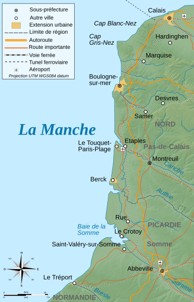
As we could find accommodation for 1 night only in the Wallonie and it was a long weekend, we've decided on our return home to see if we can find accommodation in the Baie de Somme (see the map below). Our luck was in, so after 1 night home, we left early the next morning, putting our bicycles on the back of the car.
Baie de Somme - the bay of the Somme, it is where the Somme river flows into the English Channel. The Somme is also well known for the Battle of Somme, one of the big battlefields during WWI)
The area is a natural reserve of which the Parc du Marquenterre forms the heart of it, comprising about 3 000 ha. It is an important area for migrating birds between Europe and Africa.
On the map below: we've stayed in Saint-Valéry-sur-Somme and the last day we've passed Le Crotoy to Parc du Marquenterre, north west of Le Crotoy and bordering the Channel. If you look further north on the map you'll see Le Touquet-Paris-Plage, another beautiful place and popular beach, that we have visited in 2009 when I came to visit JL. Still further north are Cap Gris-Nez and Cap Blanc-Nez, apparently beautiful, so still on my 'to visit' list.
Saint-Valéry-sur-Somme is a beautiful medieval town, situated on the estuary of the Somme. Another village where I followed the footsteps of Joan of Arc, as she was kept here in prison on her way to Rouen.
Everywhere you'll find moules frites on menus, so after some of the best mussels I've ever had, we took our bicycles to continue exploring the town and to search a restaurant to book for dinner. By now we know it is wise to book a restaurant in advance, especially if it is weekend, and so much more a long weekend!
After booking a restaurant (there weren't a lot of tables still available), we chose one of the few cycle routes and drove off to one of the neighbouring village. It is a relative young route, compared to the cycle routes of Ile de Ré, but we found it lacked some information, such as distance below the names, and it followed the road, whereas in Ile de Ré the cycle rooutes are mainly away from the main roads. However, I think their main restriction was the marshes that cover a big area.
Here we've arrived at the village, where we had a waffle, another speciality of the region. After we left the village, we took our own route for a while and it turned out that we had to take a huge turn to link back to the route again (after thinking at one stage we're lost and that I'll never make it back to the hotel! But the route eventually led us through some cattle farms which offered a much finer view than the original route)Above: strange sight, isn't it? I couldn't understand why on earth all these people are sitting on the pebbles looking out on the sea. To hear they are waiting for the phoques (seals, and in French you pronounce it 'fok'...- I guess it comes from the Latin phocidae)
Below: JL in front of our restaurant of the evening, another place you can try as we had an excellent meal with very good service
Below: JL in front of our restaurant of the evening, another place you can try as we had an excellent meal with very good service
The next morning we took the car to Parc du Marquenterre (impossible to cycle there after the long ride of the previous day). We've realised we won't have enough time to visit the park, it was either that or cycle. We've decided to return during the migration period for the park and to rather cycle. We cycle all the way to another coastal town, Quend-Plage-les-Pins, with a big sandy beach. From there it goes all the way north to Berck (see map), a popular place for surfers and hippies.


Quend-Plage-les-Pins, where we had another good meal before returning by bicycle (I needed the break!)


No comments:
Post a Comment